
Beachfront Resort District (BRD)
Sec. 78-991. – Purpose.
The beachfront resort district (BRD) is a zoning district which accommodates a mix of residential uses and seasonal resort accommodations. The building stock consists of seasonal accommodations and yearround homes. This district is characterized by low-rise development, and the district provisions are designed to maintain the lower profile of this section of the town’s beachfront. The mix of commercial and residential uses require the establishment of “good neighbor” performance standards where commercial uses and seasonal accommodations abut residential uses. These standards are found in the performance standards that are specific to the district.
Contract Zone-1 (CZ-1)
Sec. 78-2131. – Purpose.
Occasionally, traditional zoning methods and procedures such as variances, conditional use permits, and alterations to the zone boundaries are inadequate to promote desirable development. In these special situations, more flexible and adaptable zoning methods are needed to permit differing land uses in both developed and undeveloped areas, and at the same time recognize the effects of change. In consideration of a change in zoning classification for a particular property or group of properties, it may be determined that public necessity, convenience, or the general welfare require that provisions be made to impose certain limitations or restrictions on the use or development of the property. Such conditions are deemed necessary to protect the best interests of the property owner, the surrounding property owners and the neighborhood, all other property owners and citizens of the town, and to secure appropriate development consistent with the town’s comprehensive plan.
Downtown District-1 (DD-1)
Sec. 78-716. – Purpose.
The purpose of the downtown district 1 (DD-1) is to maintain the historical downtown area as the town’s principal commercial, service, and entertainment center for yearround residents and seasonal visitors, by promoting increased commercial diversity, vertical stratification of mixed uses, improved infrastructure, and implementation of design standards targeted at creating a visually exciting and harmonious environment attractive to the changing market demands.
Downtown District-2 (DD-2)
Sec. 78-746. – Purpose.
The downtown district 2 (DD-2) represents a natural expansion of the DD-1 district into adjacent underutilized parcels for the purpose of increasing the critical mass of commercial space and diversity of goods and services essential to provide for a strong local economy. Since the DD-2 district is both visually and functionally related to the traditional downtown, many of the same uses and design standards of the DD-1 district apply.
General Business-1 (GB-1)
Sec. 78-801. – Location; purpose.
(a) The general business district 1 (GB-1) shall extend along Old Orchard Road, Ocean Park Road, Temple Avenue, and Saco Avenue from the Saco town line to E. Emerson Cummings Blvd./Union Avenue, the Portland Road from Imperial Street and Cascade Road, Cascade Road from Portland Avenue to Miles Avenue and shall extend to a lot line of any lot with direct frontage on any of the streets or roads mentioned in this subsection for a maximum depth of 400 linear feet from the street centerline.
(b) The GB-1 district is intended to accommodate commercial activities that are inappropriate to the downtown due to the compact settlement pattern in the beachfront area. While the GB-1 district is slowly evolving into highway commercial area, district regulations establish site development standards that encourage expansion of commercial uses while preserving the existing building line and mixed use character of the area.
General Business- 2 (GB-2)
Sec. 78-831. – Location; purpose.
(a) The general business district 2 (GB-2) shall extend along both sides of Saco Avenue from E. Emerson Cummings Boulevard to the DD-2 district boundary at tax map 206, block 26, lot 1, and shall extend to the back property line of any lot with direct frontage on Saco Avenue for a maximum depth of 300 feet from the street right-of-way.
(b) With the density of the settlement pattern of this area, the GB-2 district is primarily designed to encourage conversion of existing residential structures to small office and retail operations that generate relatively lighter trip generation and parking demand.
Industrial District (ID)
Sec. 78-901. – Purpose.
The industrial district (ID) is established as a zoning district where the principal use of the land is for manufacturing, processing, treatment, research, warehousing, storage and distribution, excluding those uses where there is danger of explosions; chemical, radioactive, or biological contamination; or other hazards to public health or safety.
Neighborhood Commercial Districts 1, 2, 3, 4 (NC-1, NC-2, NC-3, NC-4)
Sec. 78-866. – Purpose.
The purpose of the neighborhood commercial district (NCD) is to provide for the continuation and/or establishment of businesses and services, which support and complement the character of surrounding residential neighborhoods.
Planned Mixed Use District (PMUD)
Sec. 78-1021. – Purpose.
The town is a community with a rich tradition of mixed use neighborhoods and a paucity of land area dedicated for large commercial, light industrial and institutional uses essential to bolster its nonresidential tax base and provide yearround employment opportunities. The intent of the PMUD district is to encourage creative and flexible land use design that efficiently maximizes the use of developable land while promoting the integration of new commercial and business development with supporting residential and recreational uses—all within a quality community environment.
Residential Beachfront District (RBD)
Sec. 78-1001. – Location; purpose.
The residential beachfront district shall extend from the entirety of Parcher Avenue (south), the Old Orchard Beach/Scarborough town line (north), the Guilford Line railroad tracks (west) and Atlantic Ocean (east).
The residential beachfront district is a zoning district which accommodates a mix of residential uses and seasonal resort accommodations. The building stock consists of year round homes and year-round accommodations. This district is characterized by low-rise development, and the District provisions are designed to maintain the lower profile of this section of the town’s beachfront. Instances in which existing commercial uses and seasonal accommodations abut residential homes, prior to the adoption of this section, and therefore “grandfathered”, require the establishment of “good neighbor” performance standards that are specific to the district.
Residential- 1 District (R-1)
Sec. 78-486. – Purpose.
The residential 1 district (R-1) is established as a zoning district in which the principal use of the land is for single-family residences in detached dwellings and customary accessory, educational, public and religious uses that contribute to a wholesome residential neighborhood environment.
Residential- 2 District (R-2)
Sec. 78-516. – Purpose.
The residential 2 district (R-2) is established as a zoning district in which the principal use of the land is for one- and two-family residences and customary accessory, municipal, educational and religious uses that contribute to a wholesome neighborhood environment.
Residential- 3 District (R-3)
Sec. 78-546. – Purpose.
The residential 3 district (R-3) is established as a zoning district where the principal use of the land is for single-family, private residences on small lots.
Residential- 4 District (R-4)
Sec. 78-576. – Purpose.
The residential 4 district (R-4) is established to accommodate one-family and multifamily homes, and customary accessory educational, public and religious uses associated with residential neighborhoods.
Residential- 5 District (R-5)
Sec. 78-606. – Purpose.
The single-family private dwelling district (R-5) is established as a zoning district where the primary use of the land is for single-family detached residences.
Rural District (RD)
Sec. 78-961. – Purpose.
The rural district (RD) is established as a zoning district where the land is used for a wide variety of purposes at low density and where ample land area is an essential prerequisite for establishment and conduction of most rural land uses. Preservation of its rural character to the extent possible is also one of the most important purposes of the RD district.
Zoning District Overlays:
Campground Overlay (CO)
Changes in the camping and recreational vehicle industry over the past decade have transformed the traditional summertime tent and trailer campgrounds into high density small villages with permanent facilities and resident occupancy for as much as seven months of the year. In addition, a majority of campgrounds in the Old Orchard Beach are legally non-conforming uses that are hamstrung in their abilities to expand and change with market demands. The purpose of the Campground Overlay District (CO) is to establish all existing campgrounds as conforming uses, and to provide performance and design standards that permit the expansion of existing campgrounds, and creation of new campgrounds while mitigating the on and off-site impacts created by the use.
Historic Overlay (HO)
Sec. 78-1131. – Purpose.
(a) The Portland Avenue corridor from Foote Street to Old Orchard Street is a distinctive historic character area and a visually important gateway into the downtown. With its collection of architecturally significant structures, uniform setbacks, tree-lined sidewalks, and focal view of the town hall bell towers, this portion of the Portland Avenue corridor remains one of the few surviving examples of the town in its heyday as a grand resort.
(b) The purpose of the historic overlay district (HO) is to encourage the preservation of the existing historic structures and the streetscape character that is critical to the identity and cultural welfare of the community, while promoting appropriate reuse of existing structures and encouraging new construction that is architecturally and visually compatible with the character of the district.
Amusement Overlay (AO)
Sec. 78-1081. – Purpose.
(a) The existing beachfront amusement parks and the pier have long served as a prime attraction to the summertime visitors and one of the historical signatures distinctive of the town. Both the pier and the amusement parks are unique mixed use areas that have different design configurations and land use requirements from the linear built fabric and land use patterns elsewhere in the downtown. By nature, amusement parks are flexible land uses that must shift the internal layout and complement of rides and amusements to meet market demand, the same way that a retailer changes stock with the season or with emerging fashion trends.
(b) The purpose of the amusement overlay district (AO) is to provide the flexibility of site design criteria and use requirements that will support continued operation of the amusement parks and pier by enabling operators to adjust the mix of uses and rearrange site elements in rapid response to shifting market demand.
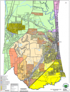
| Attachment | Size |
| Official Old Orchard Beach Zoning Map | 3.32 MB |